

Bhu Naksha Bihar: How to View & Download a Patna Land Map (2026)
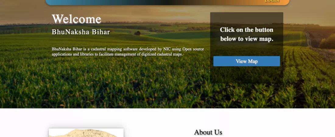
Short answer: Bihar's land maps are free to view on bhunaksha.bihar.gov.in, with no login. Press View Map, then pick District 28 PATNA, the sub-division, circle (anchal), mauza, survey type and sheet. The whole village map opens. Click your khesra, press LPM Report under Plot Info, and you get that plot's Land Parcel Map PDF free. For a printed government map sheet, order it by post from the Door Step Delivery portal: ₹285 in total for one sheet (the amount the portal showed on 16 October 2026).
We ran the whole process on a real Patna example, Digha mauza in Patna Rural circle (Patna Sadar sub-division), and every screenshot below is from that run. You will also see what each Patna circle is called on the portal (several names are not what you'd expect), which survey to pick, and what to match on the map before you buy.
What is Bhu Naksha, and why check it before buying land in Patna?
Bhu Naksha is the digitised survey map of a revenue village (mauza). Every plot (khesra) is drawn with its boundary and number. The papers (khatiyan, jamabandi, sale deed) tell you who owns the land and how much. The map tells you where it actually is: which plots it touches, what shape it has, and whether it reaches a road.
In Patna this is the check that catches a common trick: the deed is for one khesra, and the plot shown on site is a different one. Buyers who live outside Bihar are the easiest targets. Our full checklist is in the plot buying guide for Patna; this article covers only the map.
How to view Bhu Naksha Bihar: a Patna example, step by step
Have three things ready: the circle, mauza name and khesra number. They are on the khatiyan, the jamabandi or the sale deed. If you don't have them, start with the jamabandi online.
| Step | What to do | What we picked for Digha |
|---|---|---|
| 1 | Open bhunaksha.bihar.gov.in and press View Map | Map viewer with a Location box on the left |
| 2 | Choose District | 28 PATNA |
| 3 | Choose Sub Div | 02 Patna Sadar |
| 4 | Choose Circle | 04 Patna Rural |
| 5 | Choose Mauza (the number in brackets is the thana number) | 0161 Digha(1) |
| 6 | Choose Survey Type (SS, RS or CS; options differ by mauza) | SS Special Survey |
| 7 | Choose Map Instance and Sheet No | 00 First Map, sheet 00 |
| 8 | The village map loads. Zoom in with + and click your khesra | Khesra 100 |
| 9 | Plot Info on the left shows the khesra number and an LPM Report link | LPM Report → PDF |
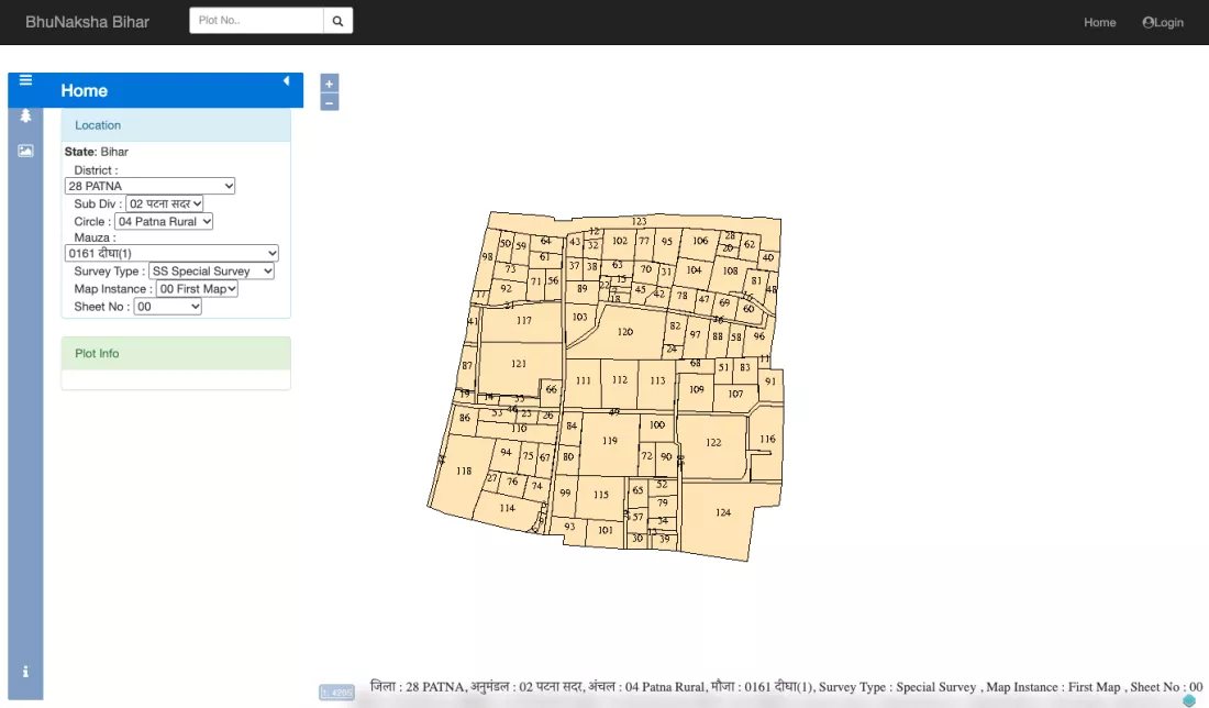
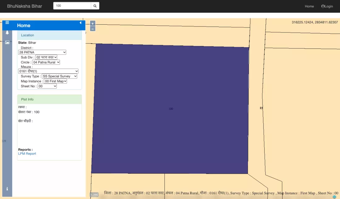
Note: there is a "Plot No." search box at the top, but when we tested it on 16 October 2026 the portal did not return a result for it. The reliable way is to zoom in and click the khesra directly on the map. In large villages the numbers only become readable once you zoom in well.
What are Patna's circles called on the Bhu Naksha portal?
All 23 circles of Patna district are on the portal, but some names differ from everyday use. The one that trips people up most: Patna Sadar circle appears as "Patna Rural", and Danapur circle as "Dinapur-Cum-Khagaul". The full list as the portal showed it on 16 October 2026:
| Sub Div | Circle names on the portal |
|---|---|
| 02 Patna Sadar | Patna Rural (Patna Sadar circle), Phulwari (Phulwari Sharif), Sampatchak |
| 03 Danapur | Dinapur-Cum-Khagaul (Danapur), Bihta, Maner, Naubatpur |
| 01 Patna City | Fatwah (Fatuha), Khusrupur, Daniawan |
| 04 Masaurhi | Masaurhi, Punpun, Dhanarua |
| 05 Paliganj | Paliganj, Dulhin Bazar, Bikram |
| 06 Barh | Barh, Bakhtiarpur, Athmalgola, Belchhi, Ghoswari, Mokameh (Mokama), Pandarak |
To find which circle your land is in, and the CO's number, see our Patna circle officer list. Mauza names are written in Hindi for some villages and in English for others, so scan the list both ways.
Survey type: SS, RS, CS or Chakbandi — which map should you open?
The portal holds two families of maps, and not every mauza has all of them. The drop-down only lists what has been uploaded for that mauza.
| Survey type | What it is | When it helps |
|---|---|---|
| CS (Cadastral Survey) | Map from the first, British-era survey | Matching a khesra on an old CS khatiyan |
| RS (Revisional Survey) | Map from the later revisional survey, where one was done | Areas with an RS khatiyan |
| Chakbandi | Map made after land consolidation, where it happened | Villages where consolidation changed khesra numbers |
| SS (Special Survey) | Map from the ongoing Bihar Special Survey | Seeing what stage the new survey is at and the new khesra |
Special Survey maps are uploaded stage by stage. The portal's home page counts them as First Map, Boundary Verified Map, Khanapuri Updated Map, Draft Published Map, Draft Final Published Map and Final Published Map, and the Map Instance drop-down shows which stage you are looking at. For Digha we only found a "First Map" under SS, so the Special Survey map there is still at an early stage. Don't treat such a map as final; only a "Final Published Map" is.
Open the map of the same survey as your khatiyan (CS or RS), otherwise the khesra numbers won't line up. Khatiyan types are explained in our Bihar khatiyan guide.
Bhu Naksha PDF download: the free LPM report (Land Parcel Map)
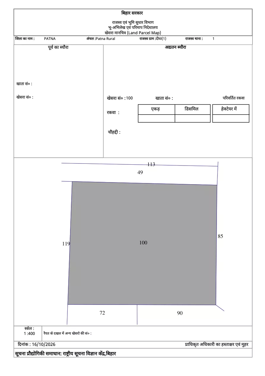
After you click a khesra, LPM Report opens a PDF in a new tab titled "खेसरा मानचित्र (Land Parcel Map)", under the header of the Government of Bihar, Revenue and Land Reforms Department, Directorate of Land Records and Survey. You can download or print it. There is no fee.
What the LPM report shows:
- District, circle, revenue village (mauza) and revenue thana number
- The khesra number and its outline, with the numbers of all adjoining khesras
- The scale (1:400 in our example) and the date it was generated
- Fields for khata number, area (acre, decimal, hectare) and boundaries (chauhaddi)
Two things to be clear about:
- In both our tests (an SS map in Digha and an RS map in Abdul Rahmanpur) the khata, area and boundary fields came out blank. So don't rely on this report for area. Take the area and the owner's name from the jamabandi and khatiyan.
- The box at the bottom, "signature and seal of the authorised officer", is empty. A downloaded LPM is not a certified copy on its own; it is for information and matching. If you need a certified copy for court or an official purpose, ask the circle office where to get one.
Get a printed government map delivered: ₹285 for one sheet
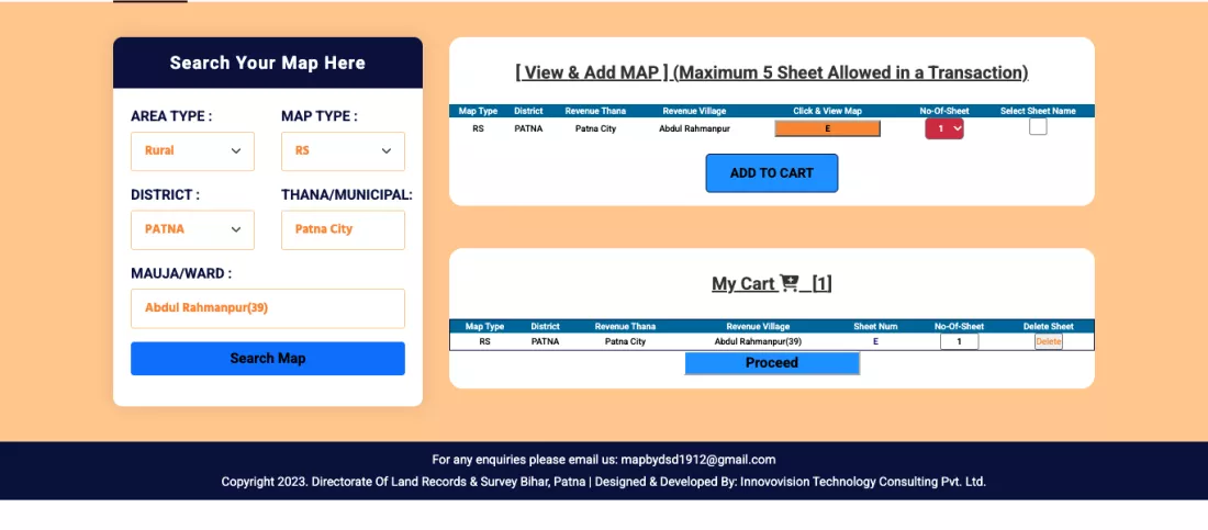
A printed map sheet of the whole mauza can be ordered by post from the Directorate of Land Records and Survey's "Door Step Delivery Of Revenue Maps" portal. You get the village sheet, not a single-plot extract. This is the process as we ran it on 16 October 2026 for Abdul Rahmanpur mauza in Patna, stopping before payment:
- Open dlrs.bihar.gov.in/dms1.
- Choose Area Type (Rural or Municipal), Map Type (CS, RS or CK for chakbandi), District: PATNA, then Thana/Municipal and Mauja/Ward. Patna's revenue thanas are listed as Mokama, Patna City, Barh, Phulwari, Danapur, Bikram, Maner, Masaurhi and Fathua.
- Press Search Map. Use "Click & View Map" to confirm it is the right sheet.
- Tick the sheet and press ADD TO CART. A maximum of 5 sheets per transaction.
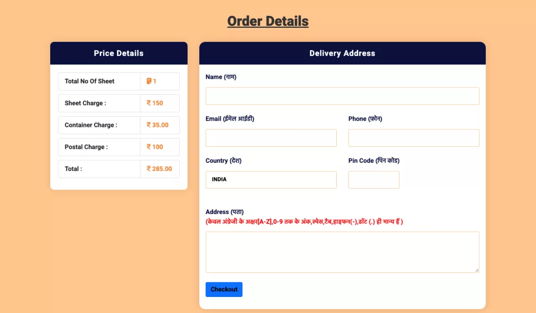
- Press Proceed. "Price Details" shows the total.
- Fill in name, email, phone, PIN code and address. The address accepts English letters only (A–Z, 0–9, space, hyphen, dot), not Hindi. Then Checkout and pay.
- Keep the receipt. Follow the order with Track Your Order on the home page.
| One sheet (portal, 16.10.2026) | Amount |
|---|---|
| Sheet Charge | ₹150 |
| Container Charge | ₹35 |
| Postal Charge | ₹100 |
| Total | ₹285 |
The portal lists an email for queries: mapbydsd1912@gmail.com.
Reading the area in kattha and dhur
Government records (LPM, jamabandi, khatiyan) mostly give area in acres and decimals, while Patna deals are struck in kattha and dhur. A quick conversion:
| Unit | Equals |
|---|---|
| 1 decimal | 435.6 sq ft (one-hundredth of an acre) |
| 1 kattha (common Patna measure) | 3.125 decimal = 20 dhur ≈ 1,361.25 sq ft |
| 1 acre | 100 decimal = 32 kattha = 43,560 sq ft |
| 1 bigha | 20 kattha |
Example: 5 decimal on paper ÷ 3.125 = about 1.6 kattha (1 kattha 12 dhur). The kattha varies a little from place to place, so treat the deed and an official measurement as final.
What to match on the map before buying a plot in Patna
| # | Check | Red flag |
|---|---|---|
| 1 | Find the deed/jamabandi khesra number on the map | That khesra is somewhere else, not where the plot was shown to you |
| 2 | Match the deed's boundaries (north, south, east, west) with the adjoining khesras on the LPM | A neighbour named in the deed is not next to the plot on the map |
| 3 | Access: does the khesra touch a road or path parcel? | The plot is boxed in by other khesras on every side |
| 4 | Shape: does the map outline look like the plot on site? | The site plot is bigger or a different shape |
| 5 | Check the khesra in both the old survey (CS/RS) and the Special Survey | The new survey shows it split, merged or recorded to someone else |
| 6 | Near the Ganga, Sone or Punpun: distance from the river or diara on the map | The khesra sits in the riverbed or diara |
One more thing: Bhu Naksha is a revenue map, not a zoning map. Check the land-use zone (residential, agricultural, green) separately in the Patna Master Plan 2031.
The map and the land don't match: what now?
- Get an official measurement: apply online on the e-Mapi portal and the circle's amin measures the land. The full process is in our Bihar land records online guide.
- If the Special Survey is running: if the new map or khanapuri parcha is wrong, dlrs.bihar.gov.in → Special Survey services has "view khanapuri parcha and khesra-wise map" plus options to file a claim or objection. Objection windows are time-bound, so don't wait.
- Ask the circle office: CO numbers for map, record or measurement issues are in our Patna CO list.
- Until the mismatch is explained, don't pay a token or advance.
- Bhu Naksha Bihar, Directorate of Land Records & Survey, Government of Bihar (NIC) — View Map, location selection (District, Sub Div, Circle, Mauza, Survey Type, Map Instance, Sheet No), Plot Info, LPM Report; survey types and Special Survey map stages — bhunaksha.bihar.gov.in
- Land Parcel Map (खेसरा मानचित्र), mauza Digha(1), Patna Rural circle, khesra 100 — generated from the portal on 16.10.2026
- Door Step Delivery Of Revenue Maps, Directorate of Land Records & Survey — search, cart (max 5 sheets), Price Details (₹150 + ₹35 + ₹100 = ₹285 for 1 sheet), English-only address — dlrs.bihar.gov.in/dms1
- Bihar Special Survey online services — dlrs.bihar.gov.in/services.html
- All portals were run and checked on 16.10.2026; all screenshots are from that day.
What should you do? (Our advice)
- Before the site visit, get the mauza and khesra from the seller, pull the LPM report, and carry it on your phone. Ask the neighbours what their khesra numbers are.
- The map alone is not enough. Confirm the owner from the jamabandi and khatiyan, and check for pending mutations with the mutation status.
- For a large deal, get an official measurement done before registry. Settling a boundary dispute afterwards costs far more.
- All our land-record guides are in the Land Records category.
Bhu Naksha Bihar: FAQs
- How do I view a land map online in Bihar?
Open bhunaksha.bihar.gov.in and press View Map. Choose District, Sub Div, Circle, Mauza, Survey Type, Map Instance and Sheet No. The village map opens; zoom in and click your khesra. No login or fee is needed.
- How do I download a Bhu Naksha Bihar PDF?
Click your khesra on the map, then press LPM Report under Plot Info. A "Land Parcel Map" PDF of that plot opens, which you can download or print. It is free, but it carries no officer's signature.
- Why can't I find Patna Sadar circle on Bhu Naksha?
On the portal, Patna Sadar circle is listed as "Patna Rural" under Sub Div "02 Patna Sadar". Likewise, Danapur circle is listed as "Dinapur-Cum-Khagaul" under Sub Div "03 Danapur".
- Why is the khesra number search not working on Bhu Naksha?
When we tested on 16 October 2026, the Plot No. search box at the top did not return results. Zoom into the map and click your khesra directly; that brings up Plot Info and the LPM Report.
- How do I get an official land map delivered at home in Bihar, and what does it cost?
On dlrs.bihar.gov.in/dms1, search your mauza, add the sheet to the cart, enter the address and pay. On 16 October 2026 one Patna sheet came to ₹285 in total (sheet ₹150, container ₹35, postage ₹100). Up to 5 sheets per order.
- What do SS, RS and CS mean on Bhu Naksha?
CS is the Cadastral Survey (the first, old survey), RS is the Revisional Survey, and SS is the ongoing Bihar Special Survey. Open the map from the same survey as your khatiyan so the khesra numbers match.
- Does Bhu Naksha show who owns the land?
Not reliably. In our examples, Plot Info and the LPM even left the khata and area blank. Check the owner and area in the jamabandi (Register-II) and khatiyan.
This article reflects what the Bhu Naksha Bihar and Directorate of Land Records & Survey portals showed on 16 October 2026. Portals, charges and steps can change — confirm the amount shown on the portal and check with the circle office before making any decision.


